And furthermore ...

One Man's Treasure encourages the use of anonymous photographs posted here to illustrate books and album covers.
If an image appeals to you, contact John Toohey at johntoohey@hotmail.com.

Saturday, 8 December 2012

HIGHWAY STAR 3


Real photo postcards from Colorado, Idaho, Montana, Wyoming and South Dakota
"Leave me alone and let me go to hell by my own route."
Calamity Jane, 1903


In America a village of 200 people can be called a city and a dirt track a highway. For years Pikes Peak Highway was just that, a stretch of gravel winding to the summit, 4300 metres above sea level. Like a lot of US highways in the first part of last century it was a privately built toll road. Why mining magnate Spencer Penrose thought in 1915 that Pikes Peak needed a highway to the top is unclear. Weather conditions could close it down for a lot of the year and when you got to the end there wasn’t much else to do except turn back and go down again. Maybe that was why he set up the Race to the Clouds the next year. It became one of the premier vehicle endurance races in the country and a testing ground for automobile companies. Bottomless Pit is near the top, just after the Devil’s Playground and before Bighorn Sheep Pullout.


The photographers who specialized in real photo views were tougher and more ruthless than we give them credit for. They marked out their territories, bought concessions and didn’t appreciate intruders. Harold Sanborn’s turf was Colorado and parts of Wyoming and Montana, hence with one exception, every postcard from these states that we’ll see came from his company. In 1995 Colorado businessman Derick Wangaard bought the Sanborn Postcard publishing Co and discovered some 40 000 of Harold Sanborn’s negatives and his journals wherein he had annotated every photo he had taken. Wangaard offered the archive to the Colorado Historical Society, which agreed it had extraordinary value but doubted they could raise the $500 000 he was asking. We’re not sure what happened after that. The usual story is that the archive gets broken up and scattered about then a few years later someone in the government realizes they lost an invaluable record of the state’s history.


A camera and a car were useful but what every itinerant photographer needed was the willingness to travel. That might sound banal but in the 1930s and 40s it meant putting up with car breakdowns, awful weather and hours of solitude behind the wheel. Often as not the photographer knew exactly what he was after and the best time to get it but there were times he chanced across a scene. This postcard was mailed in 1949 from Oakland California to Hingham in Massachusetts by ‘Meg’. She had just driven across the country and somewhere in Wyoming, probably Fort Bridger, she saw this in a rack and it reminded her of the miles of open road she had just experienced.


When the Lincoln highway system was proposed in the 1900s the planners were possessed with the notion that the route needed to be scenic. A straight route might be cheaper  but if it missed a scenic wonder the added expense in rerouting was of little concern. What was the point of driving across America if you missed all it had to offer? To cross Wyoming without passing by Tollgate Rock was like visiting Paris and skipping the Louvre. In the 1970s and 80s a new breed of planner came along. Cut costs and forget what the world looked like outside the windscreen, they said. Since government had handed responsibility to private corporations it could hardly complain.


Another view of Tollgate Rock, this one not by Harold Sanborn. Notice the highway and the speck of a car between the Rock and the cliff face in the foreground. It would have been easy to photograph Tollgate Rock from both vantage points and not include the road but this was an era of massive engineering projects and Detroit was building cars for the world. Scenic views we as much about America’s power as they were about its timeless landscape.


By 1925 the first age of the Wild West was dead and buried but the second was just climbing into the saddle. An industry built on cowboy nostalgia was hitting its strides and ranchers in Wyoming realized there was good money to be made if they diversified from sheep and cattle into tourism. For a weekend guests at dude ranches could don Stetsons, strap a lasso to their saddle and ride out along a mountain trail. At night they sat around campfires singing Big Rock Candy Mountain and She Wore a Yellow Ribbon and maybe listened to a grizzled old timer talk of Sitting Bull. Sounds unmissable, but it wasn’t. The ranches were so popular that there was soon a demand for a place of worship the guests could head to on a Sunday and so the Chapel of the Transfiguration was built. It was constructed in the Western Craftsman style, which was as authentic as a Boston accountant in woollen chaps, but never mind. It fitted with the setting. Anything else would have been either ugly or absurd.


Since we were speaking of engineering marvels and scenic wonders, a detour to the Spiral Highway in Idaho is essential. Built in 1917 to connect Lewiston with Moscow, the problem to contend with was the 2000 foot incline out of Lewiston and though it could have been solved by avoiding the hills altogether, why pass up a challenge like that? The Spiral Highway wasn’t quite a folly - the point to so many curves was to slow traffic down to a manageable 30 mph – but try to imagine the detail involved in the surveying and engineering. It did inspire at least one song; Hot Rod Lincoln by Charlie Ryan, a 1955 answer song to Hot Rod Race. The basic premise was that Californian hot rodders were all talk until they’d taken on the Spiral Highway.


Gardiner, Montana, population about 850 and entrance to Yellowstone National Park, which officially begins once you have passed through the Roosevelt Arch to the left of the photo. Sanborn took this photo in the 1940s and though the neon signage has gone, the cars have long since turned to rust and we can assume the dog passed away some time back, most of what you see still survives. But for how long? Some scientists claim the next time the subterranean volcano bubbling away under Yellowstone blows its stack it will wipe out Montana, Colorado and most of Nevada. Since the last eruption was 640 000 years ago, another is due, maybe tomorrow.


Assuming Yellowstone’s volcano doesn’t blow its stack, by the time you read this, the Two Medicine River Bridge in Montana will have been dismantled anyway, its structural flaws making restoration a waste of time and money. It was only built in 1940 so arguments about its heritage value are a little thin and the plans for the replacement suggest that won’t completely ruin the view. Two Medicine River has its place in American history as the only site where the Lewis and Clark expedition had a violent conflict with Native Americans. Guess who started it. Lewis, the one with the flaky sounding first name, told a group of Piegan people he intended to sell guns to the Shoshone, their long time enemies. (Arms trade was already big business in America; the Piegan controlled the region’s gun market so Lewis was effectively threatening to break their monopoly.) Two casualties, both Piegan, and another omen of what was to come.


Into South Dakota, and if the number of postcards floating about the internet is any indication the Badlands were the most photographed area in the USA between 1930 and 1960. Why that should be is only speculation though geographically they were the entrance to the West for the north-eastern cities and a relatively short drive from Chicago and Minneapolis. Rise Studio was run by optometrist Carl H. Rise until his death in 1939 though it remained in operation until ‘fairly recently’, whenever that may mean. 


On some of Rise’s postcards this stretch is labelled ‘Satan’s Speedway’, which is much better than ‘road scene’. Once again we have a magnificent landscape serving as a mere backdrop to a photo of a highway, but who is to complain? Remove the road and you would think something was missing from this image. Rise was born in South Dakota in 1887, ten years after the Battle of Little Bighorn and the death of Crazy Horse. Deadwood’s heyday had passed but Calamity Jane was very much alive. It’s unlikely anyone thought they had lived through an era that would become mythical. They probably welcomed progress, whether that was a railway, running water or a dirt road. The point is, when he took his photos, Rise could remember a time when cars let alone highways were unimaginable in the back parts of Dakota. 


In 1937 21 year old amateur herpetologist Earl Brockelsby figured he could make money from his hobby by opening a roadside attraction. Back then, not long before this photo was taken, the idea was that travellers would pull in off the highway, buy a soda and look at the rattlers slithering about in their cages, which was more fun than finding one in your sleeping bag. These days the Black Hills Reptile Garden claims to have the largest collection of venomous reptile species of any zoo in the world and to be internationally recognized for its work in protecting species. 


 Which is the better prospect for getting you to pull off the road, a hissing snake showing off its fangs or a fake tree? Another of Brocklesby’s ventures was the nearby Skyline Petrified Forest, which didn’t have quite the same success as the Reptile Garden. This giant log, which stood at the entrance to the park, was basically a timber frame with a concrete and wire façade. It burned down in 1965 and wasn’t replaced. Had it survived, doubtlessly it would now be venerated along with the concrete dinosaurs, cowboy towns and giant portraits of four presidents and one Lakota warrior that, depending on your point of view, enhance or disfigure South Dakota’s landscape. It is time to leave the American West, to head south to the flyover states.

HIGHWAY STAR 3

Saturday, 17 November 2012

HIGHWAY STAR 2


Marshall McLuhan

Real photo postcards of Nevada, Utah, Arizona and New Mexico


 I went to Reno once, thinking for some reason it would be like this photo, but all I got was a late 20th century version of Dante’s Inferno. So let’s leave and head out on Highway 40, as it was then known. But before we do: an earlier post had some photos by the same company, described then as ‘unknown photographer’ but which we now know was the Nevada Photo Service, run by Lawrence Engel. Born in Wisconsin the 1890s, Engel fought in the Mexican Revolution, against the Mexicans, probably just before he arrived in Nevada in the 1920s. He began Nevada Photo Service as a photo finishing business but built it up to, among other things, the most prolific photographic company in the state, until he drowned in a boating accident in 1953. His obituary – the best place to find information about respectable citizens of small town America – suggests the company was state wide with several branches, meaning he wasn’t the only photographer, but if so the company’s stock showed remarkable consistency. There’s a particular look to Nevada Photo Service images. The scenery isn’t spectacular; the scenes suggest long hours on straight roads that the driver knows all too well. 


In the 1910s and ‘20s Nevada was a sinner’s paradise. The laws regarding gambling, prostitution and divorce fluctuated but the state was always amenable. Outside of mining, they were the only reasons anyone would want to stick around. Most people on the roads were just passing through. When the Lincoln Highway Association was formed in 1912 with the idea of developing a highway from New York to San Francisco it expected a few fights with the states but none were as fractious or threatening to the scheme as Nevada’s. The choice lay between a route that entered at Wendover then followed the old California Trail through Elko, Lovelock and Winnemucca to Reno, or one that cut south to Ely, to Austin and Fallon, before arriving in Reno. At stake was the prospect that whichever route lost out stood to lose most of that migrating traffic. At one point things got so bad the LHA considered avoiding Nevada altogether and putting the route through Arizona until straitlaced, teetotalling Mormon Utah raised a stink. Some of its residents wanted access to Reno. In the end Ely got the Lincoln Highway, but did that help? In terms of getting to Reno from Utah there wasn’t a lot of difference but the Elko route had the railway, it had history and it was better looking.


Historians are vague as to how Battle Mountain got its name, but this being a border between Shoshone and Paiute land and an area rich in minerals you can probably guess. (Speaking of Paiutes, Winnemucca on Route 40 was named after Sarah Winnemucca, teacher, activist and the first Native American to publish a book,) Reading the promotional literature coming out of Battle Mountain, you’ll catch a distinct, plaintive tone, which isn’t surprising given that after 150 years of mining the landscape has been gutted and there aren’t many reasons left why a tourist would want to go there. The Paiute weren’t the only people to suffer at Battle Mountain. In the 1920s, ‘red’, i.e. union affiliated, miners had confrontations with their employers, or to put it another way, were beaten, shot at and otherwise brutally victimized on the orders of industrialists who thought organized labour was un-American. Maybe that’s why Battle Mountain had its initials impressed on its side. Its history was too violent to ignore.


It’s sunset and we’re heading towards the Utah border, in the opposite direction to the wagon trains of pioneers who started appearing in these parts a hundred years earlier. They didn’t think much of Nevada; not enough that they’d want to settle down. If this image looks familiar it’s because Dorothea Lange, Walker Evans, Robert Frank, Stephen Shore etc, all parked their cars and stood in the middle of a lonely highway stretching to infinity. The difference was that for them it was a new road and a new revelation. For Nevada Photo Service this highway was as familiar as a cough to an old smoker. Sometimes, you think, when the day was drawing to a close and reception was fading on the car radio, a pattern in the clouds or the colour of the sun on the desert changed everything.


Utah. Land of the Saints; the driest state, which was sad news if you were thirsty because you could go for hours without seeing a bar. Even coffee was hard to find. It was a state without much to attract the unconverted until copper was found in Bingham Canyon. The Bingham Copperfield Tunnel ran for a mile and a quarter through the mountains to the town of Bingham and for reasons even the engineers might not have understood it was one way only. Think about it. Before the lights at one end could change the tunnel had to be emptied of oncoming traffic and once the cars could enter they had to proceed at a slow pace through the dimly lit passage. You could be waiting at the other end for half an hour before you were let through. And look at the dust coating some of the cars. It was only a short drive from Salt Lake City but it’s a good thing miners weren’t obliged to carry guns.


And this was what awaited on the other side. Bingham reminds me of the mining town in Dashiell Hammett’s Red Harvest. “I first heard Personville called Poisonville by a red-haired mucker named Hickey Dewey in the Big Ship in Butte.” Maybe it wasn’t as corrupt but it looks like a place that had its own rules. It’s gone now. Everything in this scene has disappeared, even the mountains in the background. The mine is still there. It is one of the biggest man-made holes on the planet. Have a look at it on Google Maps. 


Wellton Arizona didn’t have much to pull the traffic over in the 1940s but there was Ralph’s Mill, where you could get gas, coffee and maybe some advice from the kid behind the cash register. Most people on the road were travelling between Yuma and Tucson; living the dream, if that happened to be a western starring Joanne Dru and Dan Duryea. Not much more can be said about Ralph’s Mill but we know a bit about the photographer Burton Frasher. Long before Ansel Adams and Edward Weston set out, Frasher was travelling the roads of the American southwest taking photographs of the landscape he turned into postcards. Before his son died in the late 1990s he handed over his father’s archive of more than 60 000 negatives to the Pomona Library. Frasher’s postcards are distinctive for their sharp detail and clear tonal range. He must have used a large format camera to achieve that quality.


Maybe it’s the name but you expect that anything that happens in Gila Bend, is bad and setting foot in a café like this is the beginning of something that won’t end well. This postcard was sent to Fort Worth, Texas, sometime in the 1940s by a woman called Stella. She wrote: “ … We ate breakfast here. Floyd said helo (sic). Mother please don’t say any more about S S and my trouble. S S got hold (told?) of it at Coleman he didn’t like it. So mother I love you and Daddy tell Daddy to be careful.” Some people have to write a whole book to achieve that much pathos.


Given all that Arizona had – the Grand Canyon, Sedona, the Painted Desert, Route 66, just for starters – you are forgiven for wondering why the photographer thought this photo would make a saleable postcard. Maybe after hours of driving through rust coloured canyons and stony desert littered with giant saguaro he just got sick of nature. What he really longed for was the concrete and straight lines of civilization. Years later, about thirty of them, a small army of photographers would move in on Arizona and look for scenes like this as being emblematic of the new West. They weren’t wrong, but when you see images like this you wonder if the art critics were hyperventilating when they called The New Topographics a radical departure.


Here’s a partial list of actors who have played Doc Holliday: Victor Mature, Kirk Douglas, Arthur Kennedy, Adam West, Jason Robards, Stacy Keach, Dennis Hopper, Willie Nelson, Val Kilmer, Dennis and Randy Quaid. Not having seen them all it’s hard to say who would be the most credible as a 5 foot 10 emaciated sociopath with severe alcohol and opiate addictions. Like the gunfight at the OK Corral, Holliday made a brief appearance in Tombstone but it is forever associated with him. When this photo was taken, Tombstone was a functioning town with a colourful past and the Crystal Palace just a long standing hotel. The touristic renovations began in the late 1960s and today, judging by more recent photos, it’s a bit like Victor Mature playing Doc Holliday – a real test of our gullibility.


Speaking of art, we’re in White Sands, New Mexico and considering if this was an attempt at it. Did the photographer see the shape of the dunes mirrored in that of the car and was each detail down to the woman on top of the dune conceived before the shutter was snapped? The viziers deciding what was art in the 1950s were certain postcards couldn’t be but if anybody in their little canon had tried this scene there’s no doubt the composition would be rich in irony etc. If we want to call it art we have to think of modernism, and ‘modernism’ and ‘New Mexico’ in the same sentence can only mean one thing. Not long before this photo was taken, the first atomic bomb was detonated a few miles down the road at Jornada del Muerto. You have to wonder if the photographer or the woman on top of the hill thought of that, not in terms of art but their physical well-being.
Maybe the air is cleaner in Colorado.

VIEW THE GALLERY HERE
HIGHWAY STAR 2

Thursday, 8 November 2012

HIGHWAY STAR


Postcards of US highways from Washington to California

“Our battered suitcases were piled on the sidewalk again; we had longer ways to go. But no matter, the road is life.”
Jack Kerouac


Before the US had highways it had routes and roads, and before them, trails. Some of those had been charted by trappers and wagon trains and most started somewhere in the east to end up on the west coast. The basic network that would become the highway system was in place before the arrival of the automobile and when the highways were being mapped out in the 1910s it made sense to stick to the pioneer trails because they followed the most accessible courses and they were where the towns had sprung up. When Americans seriously started taking to the road in the 1930s it wasn’t always with the awareness that the routes were the same their grandparents took four months to cross, assuming they survived typhoid and yellow fever.
When the Grand Coulee Highway was officially opened on May 13 1934, it was praised for being the most scenic in the country. Today the name exists in a short strip cutting through Grand Coulee, itself overshadowed and some might say only surviving, because of the dam. 


Still on the Grand Coulee Highway. All these Washington photos are all by J Boyd Ellis, former schoolteacher who tried his hand at wedding photography before nature called. People are inclined to dismiss scenic views as kitsch, but kitsch implies a vapid or false sentimentality, which I don’t see here. True, they are too few to be considered a real sample of Ellis’ photographs – like a lot of photographer’s we’re going to meet on our road trip, he published thousands as postcards - but they have a definite enthusiasm for the highway. This was taken in the 1940s, when cars were relatively cheap, gas exceptionally so and America swelled with patriotic pride. All that is in this scene: the Texaco billboard, the tyre marks on the asphalt and the underlying message that this is a great land you have to get out and take a look at; a notion that had a much shorter life span than people imagined.


Originally the Sunset Highway was a wagon road laid out with timber sleepers, and because it provided access through Snoqualmie Pass and a direct route to Seattle, it gave the city eminence over Portland. When the highway was built in the 1920s, it was famous for its switchbacks, much loved by motor heads until they lost control and plummeted over the edge. Though just over 12 miles long, it was part of a system that linked Chicago to the Pacific. All that is interesting but this photo gets to the point of what this post is about. In the 1940s the landscape of the US northwest may have been spectacular, but it was nothing without a streak of black tarmac cutting through. What did Americans love more, their country or their cars? It was a close call.


The pioneers might have been scared of Indians – they were told to be – but the real dangers were disease and becoming trapped in the mountains. The Rockies stood sullenly in their way, like grim bouncers in a nightclub doorway, and you don’t read too much from the early crossers about the glorious views looking over the peaks. Mostly they shivered and prayed and scratched entries into their diaries about how the folks in the neighbouring wagon buried their youngest last night. There was no Summit Inn to welcome them once they got to the top. 


Roads in Washington don’t stretch on forever. They twist around, following river systems, rise up through hills and mountain passes and generally think of themselves as interesting. Some thirty years after this photo was taken, a generation of photographers would come along for whom the tarmac and the powerline would represent urban degradation and the destruction of the wilderness. What did J. Boyd Ellis see in this scene? Probably a sunny spring day.


Heading south from Washington into Oregon, the most beautiful of the American states (according to its residents), with three mountain ranges, the Columbia River, a desert, wild coastline and a lot of trees, relatively speaking. It also has the Bridge of the Gods. Despite the grand name it wasn’t considered an exceptional feat of engineering, not compared to other structures being built in the 1920s. The original Bridge of the Gods was a landslide that had occurred recently enough to enter indigenous folklore and which dammed the Columbia River. The bridge links Washington with Oregon and the Columbia River Highway. You can’t talk about Oregon’s early highways without mentioning Sam Hill, Quaker, philanthropist, inveterate traveller and champion of good roads. Frequently depicted as an eccentric and a genius, he was more likely an astute businessman who realized in the 1910s that the prosperity of the northwest depended on a proper road system. Oddly enough, most politicians ignored him so he built the first asphalt road in the area out of his own pocket. He also built Maryhill Stonehenge, which sounds like a typical American roadside folly but was a respectable monument to the fallen soldiers of World War 1.


While Ansel Adams campaigned for pure photography and insisted justice couldn’t be done to the American landscape without using his zone system, the less intense were happy to buy a Sawyer’s postcard for a penny, and they probably reckoned they got more for their money. Coming out of Portland, Carlton Sawyer was only running his studio for a few years in the 1910s before he sold it, the new owners keeping the name. The same company later invented the Viewmaster. The big difference between a Sawyer's photo and one by Adams wasn’t so much technique or printing method but rather, Adams generally shunned the highway, Sawyer's celebrated it. So long as you have a car and a tank full of gas, the company was saying, you don’t need us. Get out and see America for yourself.


The two people you were most likely to encounter in real photo postcards of Oregon were Arthur Cross and Edward Dimmitt. From 1916 they travelled along Oregon’s highways snapping the landscape but they showed more initiative than most. Not happy enough with selling their postcards in the racks at local gas stations and hotels, they went to the spots tourists were most likely to gather and set up a stall from their car. They could appreciate a good view as much as the next person but they knew that the drive was the real experience and a photo captured nothing if it didn’t include the road. This is a good one, the white barrier lending what the critics would call a subtle touch to the scene.


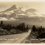
“Go where you may, within a radius of from fifty to a hundred miles or more, there stands before you the colossal cone of Shasta, clad in ice and snow, the one grand, unmistakable landmark - the pole - star of the landscape.”
That was John Muir writing in 1888. He wasn’t the only European to feel the spiritual pull of this geographic anomaly, which rises alone on a coastal plain. In the 1930s, not long before this photo was taken, Guy Ballard was hiking on the mountain when he met a man who was either Count Saint Germain or a Lemurian. One thing led to another, as so often happens, and soon Ballard was leading an esoteric cult with a membership claimed to be in the tens of thousands gathering annually at the mountain’s base. I prefer this image of Shasta. You still have the impression it is a special place and there is a road worth taking, only the revelation will be less about self-importance, more about insignificance.


Spare a thought for Lewis Mumford. In the 1950s he was warning that the highway system would ruin small towns, suck the soul out of major cities and destroy any genuine sense of community, and it was his tragedy that he died in 1990 having seen his prophecies come true. But they sounded ridiculous when he first made them. For Americans with cars highways were the nervous system of the country and the notion that it was a bad thing to be able to drive from Chicago to Los Angeles on one seamless road sounded bad itself. Note the caption: “Mt Lassen from Red Bluff, California”. Actually it’s a photo of a viaduct on one of the few straight stretches of Highway 36. It looks like Jervie Henry Eastman was so taken by the juxtaposition of the road and the mountains that he got out of his car and stood on the sidewalk to take this.


Heading south before we turn up again we hit the Joshua Tree National Park, and the Mojave Desert; stage set for countless westerns, haunt of ancient spirits and modern mystics and a place of pilgrimage for Gram Parsons worshippers, but he was likely just a baby in Florida when this was taken. Interesting that someone wrote on the front of the card without posting it. People did buy postcards because it saved them the trouble of taking photographs. Maybe someone picked this up in a roadhouse and figured they couldn’t do better themselves.


Eastman admired the Californian landscape but I think he loved its highways, gas stations, motels and small towns. He was a commercial traveller whose trade was photography and people in itinerant occupations quickly learn to appreciate the little comforts, like the diner that serves a decent coffee and the motel with air conditioning. The landscape will always be there but the barmaid who serves a larger slice of pie to the regulars will move on. Most of California’s famous photographers – there are quite a few of those – made their reputations concentrating on a specific area but Eastman covered the state, leaving an archive of thousands of photographs, including postcards of small towns like Loyalton that wouldn’t earn a glance from most people. Why? Obviously, since he was in the business of making postcards he’d want to offer a comprehensive selection but who would be after a scene of Loyalton’s main street, especially when it was overshadowed by the spectacular Sierra Nevada just a few miles away? I suspect he had an obsession, call it a personal responsibility if you want, to photograph the state in encyclopaedic detail. No town could be left out and if no one ever bought a postcard of Loyalton it didn’t matter because he had done his work. Loyalton is on the east side of the Sierra Nevada, not far from where the Donner Party began their ascent to starvation and cannibalism in 1846. Using Google Street View and taking the hill in the background as a locus, this looks like Main Street viewed from the corner of Railroad Ave. The Golden West Hotel still stands and it is possible the shopfront with the barber poles does too, but little else. Reno lies just across the border.  


HIGHWAY STAR