An amateur
photographer goes to Panama in 1915
“My impression about the Panama Canal is that the great
revolution it is going to introduce in the trade of the world is in the trade
between the east and the west coast of the United States.”
William H. Taft

In 1915 someone, or more likely a group of people, set out
to experience the best America had to offer, which that year meant the Panama-Pacific International Exposition in
San Francisco and the opening of the Panama Canal. The result is this bundle of
photographs. Crudely printed on printing out paper and heavy, fibre based
paper, they have the quality of work carried out in a home darkroom, by someone
who was yet to master the trickiest part of amateur photography. Some of them
may have turned out to be excellent images had they been finished by someone
who knew what he or she was doing, but high standards aren’t a synonym for
interesting.

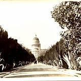
Take this shot of
the Washington Monument: an object lesson in why someone needed to have read
the Kodak photography made easy manual, but there are so many millions of
photographs of the monument that get everything right. Do we really need any
more dusk or night shots? Finally we have one that catches the eye.

There is a gap in
the sequence between Washington and California. That’s a shame because if we
follow the logical progression from Washington to Panama, through the Sierra
Nevada, it means they probably drove across the country. Bear in mind that in
1915 that meant unreliable cars on unsealed roads, for at least a couple of
weeks. Not many were willing to try that. Unless I have made a mistake in
identifying a couple of photos, this image comes next. The sign on the garage
indicates it is Lassen County, up in the Sierra Nevada and one of the most picturesque
areas in California. There’s a small ‘school’ of photographers: Jervie Henry
Eastman, Lawrence Engel and Burton Frasher (kind of), who started out in the
county’s timber industry and took up photography in their spare time until they
learned to make a profit from it.

Eagle Lake in Lassen
County. All of these prints are 4x7 inches, which makes a difference when you
realize how large this one is. Its one that breaks all the rules in the Kodak
photography made easy manual: subject too far away, too much white space,
ignorance of the rule of thirds etcetera, but would they have improved it?

Richardson Springs,
just over 100 miles south west of Susanville, Lassen County, and one of several
hot springs in the Sierras that were drawing the tourists in the 1910s. There
are a couple of postcards going on Ebay taken from a similar point of view. Did
our photographer think about buying one then realized he or she could do better
themselves?

An unknown town,
somewhere. Like some others, this has the typical light, yellowish look of
printing out paper. The uneven printing supports the theory. Like the scene
from Eagle Lake, it doesn’t break the rules so much as show ignorance of them.
Good.

We’ve arrived in San
Francisco, in time for the Panama Pacific Expo, but before we go there, let’s
head to Ocean Beach and to Seal Rocks, (note the swell) and to …

The view from Cliff
House. So much to look at in this view. In the distance we get the windmills at
the edge of Golden Gate Park, the crowds on the beach, the cars, the
smokestack, and the curious looking structures on the sands are likely to be
building materials for the sea wall that was being constructed.

Here, on the cliffs
above the beach we have the Sutro Baths before they were a ruin. There’s an argument that in the late 19th century capitalism
achieved a kind of social apogee. This was the so-called gilded age, when
wealthy industrialists ameliorated their extravagance by returning some of
their gains to the people in the form of universities, opera houses and
museums. The Sutro Baths are often cited as an example. Having made his fortune
exploiting labour, Adolph Sutro showed his benevolence by building venues for
public entertainment across the city. Historians who don’t hold back on Leland
Stanford, who see his altruism as little more than self-aggrandisement, reserve
some affection for Sutro.

This one makes me
think our photographer was Canadian. Well, given the photos were bought in
Montreal, you might expect that, but without this image we’d have no real
reason to think so. It’s hard to imagine an American showing special interest
in the Canadian Hall at the Expo.

What was it about
international expositions that dictated the architecture had to look as tacky
as it was ostentatious? Right at the moment when neo-classical architecture was
being derided as outmoded and bombastic, the one place you could still find it
was at a world’s fair, which was supposed to celebrate the modern world. We can
probably blame the 1893 World’s Fair in Chicago, though the Parisians deserve a
finger pointed their way as well. Here we have a view of the Tower of Jewels
that completely fails to express any of the grandeur the building was supposed
to have. It looks like it was built out of papier-maché.
Here’s an extract
from a brochure, sourced from the Virtual Museum of the City of San Francisco.
It says it all:
“An
expenditure of fifty million dollars in construction.
Fifty millions more in the
intrinsic value of exhibitions.
Six hundred and twenty-five acres of Palaces and gardens entrancingly beautiful.
Eleven great Exhibit Palaces crowded with objects of interest from every portion of the globe.
Spacious courts and miles on miles of ornamented avenues.
More than two hundred and fifty groups of statuary by world’s masters.
Huge mural paintings, masterpieces by the greatest artists.”
That means money, size, more money, even bigger sizes, and no
accounting for taste.

The choice of San Francisco as
venue for the World Expo in 1915 had a lot to do with the Panama Canal, but
just down the road at Balboa Park, San Diego had the more official event; the
Panama-California Exposition. For political and military historians, the U.S
entry into World War 1 is a watershed in the nation’s inexorable rise to global
domination, but economic historians look more to the opening of the Canal a
couple of years earlier. Taft was right when he suggested European trade
wouldn’t be greatly affected by the Canal, except that it secured American
authority over the Atlantic and Pacific seaboards.

The very brief account of the
Canal goes as follows: Under the directorship of Ferdinand de Lesseps, the
French begin construction in 1881. Tens of thousands of workers are killed by
malaria and industrial accidents. It is generally considered a fiasco. In 1903
President Theodore Roosevelt annexes Panama with a naval blockade. A succession
of engineers are appointed to oversee the project. Most who visit the site wisely
resign as soon as possible. The project is bigger and more complex than anyone,
including Roosevelt, imagined …

This synopsis makes no mention of
the ways debate about the Canal fractured U.S Congress, the creative economics,
the figures showing that black workers were ten times more likely to die from
yellow fever and malaria than white workers, and various other statistics that
baffle the imagination. All that is put aside when the Canal is officially
opened in August 1914. It is widely acclaimed as one of the great engineering
triumphs in world history. It is this point – the fact America could pull off
what Europe couldn’t – that really establishes the nation in international
consciousness as the power to reckon with.

The 1915 Expo and the construction of the Canal were well documented by professional photographers. Amateur views are much less common. Even rarer are collections like this that give them a shared context, and suggest a bigger story of a journey across the U.S. If the view of the Washington Monument came at the end of the journey, there’s still a sense of people heading out to document the country and be witness to its history.
 |
| CANAL DREAMS |


