Postcards of US highways from Washington to
California
“Our
battered suitcases were piled on the sidewalk again; we had longer ways to go.
But no matter, the road is life.”
Jack Kerouac

Before the US had highways it had routes and roads, and
before them, trails. Some of those had been charted by trappers and wagon
trains and most started somewhere in the east to end up on the west coast. The
basic network that would become the highway system was in place before the
arrival of the automobile and when the highways were being mapped out in the
1910s it made sense to stick to the pioneer trails because they followed the
most accessible courses and they were where the towns had sprung up. When
Americans seriously started taking to the road in the 1930s it wasn’t always
with the awareness that the routes were the same their grandparents took four
months to cross, assuming they survived typhoid and yellow fever.
When the Grand Coulee Highway was officially opened on May
13 1934, it was praised for being the most scenic in the country. Today the
name exists in a short strip cutting through Grand Coulee, itself overshadowed
and some might say only surviving, because of the dam.

Still on the Grand Coulee Highway. All these Washington
photos are all by J Boyd Ellis, former schoolteacher who tried his hand at
wedding photography before nature called. People are inclined to dismiss scenic
views as kitsch, but kitsch implies a vapid or false sentimentality, which I
don’t see here. True, they are too few to be considered a real sample of Ellis’
photographs – like a lot of photographer’s we’re going to meet on our road
trip, he published thousands as postcards - but they have a definite enthusiasm
for the highway. This was taken in the 1940s, when cars were relatively cheap,
gas exceptionally so and America swelled with patriotic pride. All that is in
this scene: the Texaco billboard, the tyre marks on the asphalt and the
underlying message that this is a great land you have to get out and take a
look at; a notion that had a much shorter life span than people imagined.

Originally the Sunset Highway was a wagon road laid out with
timber sleepers, and because it provided access through Snoqualmie Pass and a
direct route to Seattle, it gave the city eminence over Portland. When the
highway was built in the 1920s, it was famous for its switchbacks, much loved
by motor heads until they lost control and plummeted over the edge. Though just
over 12 miles long, it was part of a system that linked Chicago to the Pacific.
All that is interesting but this photo gets to the point of what this post is
about. In the 1940s the landscape of the US northwest may have been
spectacular, but it was nothing without a streak of black tarmac cutting through.
What did Americans love more, their country or their cars? It was a close call.

The pioneers might have been scared of Indians – they were
told to be – but the real dangers were disease and becoming trapped in the
mountains. The Rockies stood sullenly in their way, like grim bouncers in a
nightclub doorway, and you don’t read too much from the early crossers about
the glorious views looking over the peaks. Mostly they shivered and prayed and
scratched entries into their diaries about how the folks in the neighbouring
wagon buried their youngest last night. There was no Summit Inn to welcome them
once they got to the top.

Roads in Washington don’t stretch on forever. They twist
around, following river systems, rise up through hills and mountain passes and
generally think of themselves as interesting. Some thirty years after this
photo was taken, a generation of photographers would come along for whom the
tarmac and the powerline would represent urban degradation and the destruction
of the wilderness. What did J. Boyd Ellis see in this scene? Probably a sunny
spring day.

Heading south from Washington into Oregon, the most
beautiful of the American states (according to its residents), with three
mountain ranges, the Columbia River, a desert, wild coastline and a lot of
trees, relatively speaking. It also has the Bridge of the Gods. Despite the
grand name it wasn’t considered an exceptional feat of engineering, not
compared to other structures being built in the 1920s. The original Bridge of
the Gods was a landslide that had occurred recently enough to enter indigenous
folklore and which dammed the Columbia River. The bridge links Washington with
Oregon and the Columbia River Highway. You can’t talk about Oregon’s early
highways without mentioning Sam Hill, Quaker, philanthropist, inveterate
traveller and champion of good roads. Frequently depicted as an eccentric and a
genius, he was more likely an astute businessman who realized in the 1910s that
the prosperity of the northwest depended on a proper road system. Oddly enough,
most politicians ignored him so he built the first asphalt road in the area out
of his own pocket. He also built Maryhill Stonehenge, which sounds like a
typical American roadside folly but was a respectable monument to the fallen
soldiers of World War 1.

While Ansel Adams campaigned for pure photography and
insisted justice couldn’t be done to the American landscape without using his
zone system, the less intense were happy to buy a Sawyer’s postcard for
a penny, and they probably reckoned they got more for their money. Coming out
of Portland, Carlton Sawyer was only running his studio for a few years in the 1910s before he sold it, the new owners keeping the name. The same company later invented the Viewmaster. The big
difference between a Sawyer's photo and one by Adams wasn’t so much technique or printing method but
rather, Adams generally shunned the highway, Sawyer's celebrated it. So long as
you have a car and a tank full of gas, the company was saying, you don’t need us. Get out and see America for yourself.

The two people you were most likely to encounter in real
photo postcards of Oregon were Arthur Cross and Edward Dimmitt. From 1916 they
travelled along Oregon’s highways snapping the landscape but they showed more
initiative than most. Not happy enough with selling their postcards in the
racks at local gas stations and hotels, they went to the spots tourists were
most likely to gather and set up a stall from their car. They
could appreciate a good view as much as the next person but they knew that the drive was the real
experience and a photo captured nothing if it didn’t include the road. This is
a good one, the white barrier lending what the critics would call a subtle
touch to the scene.

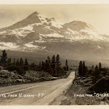
“Go where you may,
within a radius of from fifty to a hundred miles or more, there stands before
you the colossal cone of Shasta, clad in ice and snow, the one grand,
unmistakable landmark - the pole - star of the landscape.”
That was John Muir writing in 1888. He wasn’t the only
European to feel the spiritual pull of this geographic anomaly, which rises
alone on a coastal plain. In the 1930s, not long before this photo was taken,
Guy Ballard was hiking on the mountain when he met a man who was either Count
Saint Germain or a Lemurian. One thing led to another, as so often happens, and
soon Ballard was leading an esoteric cult with a membership claimed to be in
the tens of thousands gathering annually at the mountain’s base. I prefer this
image of Shasta. You still have the impression it is a special place and there
is a road worth taking, only the revelation will be less about self-importance,
more about insignificance.

Spare a thought for Lewis Mumford. In the 1950s he was warning
that the highway system would ruin small towns, suck the soul out of major
cities and destroy any genuine sense of community, and it was his tragedy that he died in
1990 having seen his prophecies come true. But they sounded ridiculous when he
first made them. For Americans with cars highways were the nervous system of
the country and the notion that it was a bad thing to be able to drive from
Chicago to Los Angeles on one seamless road sounded bad itself. Note the
caption: “Mt Lassen from Red Bluff, California”. Actually it’s a photo of a
viaduct on one of the few straight stretches of Highway 36. It looks like
Jervie Henry Eastman was so taken by the juxtaposition of the road and the
mountains that he got out of his car and stood on the sidewalk to take this.

Heading south before we turn up again we hit the Joshua Tree
National Park, and the Mojave Desert; stage set for countless westerns, haunt
of ancient spirits and modern mystics and a place of pilgrimage for Gram
Parsons worshippers, but he was likely just a baby in Florida when this was
taken. Interesting that someone wrote on the front of the card without posting
it. People did buy postcards because it saved them the trouble of taking
photographs. Maybe someone picked this up in a roadhouse and figured they
couldn’t do better themselves.

Eastman admired the Californian landscape but I think he loved
its highways, gas stations, motels and small towns. He was a commercial
traveller whose trade was photography and people in itinerant occupations
quickly learn to appreciate the little comforts, like the diner that serves a
decent coffee and the motel with air conditioning. The landscape will always be
there but the barmaid who serves a larger slice of pie to the regulars will
move on. Most of California’s famous photographers – there are quite a few of
those – made their reputations concentrating on a specific area but Eastman
covered the state, leaving an archive of thousands of photographs, including
postcards of small towns like Loyalton that wouldn’t earn a glance from most
people. Why? Obviously, since he was in the business of making postcards he’d
want to offer a comprehensive selection but who would be after a scene of
Loyalton’s main street, especially when it was overshadowed by the spectacular
Sierra Nevada just a few miles away? I suspect he had an obsession, call it a
personal responsibility if you want, to photograph the state in encyclopaedic detail.
No town could be left out and if no one ever bought a postcard of Loyalton it
didn’t matter because he had done his work. Loyalton is on the east side of the
Sierra Nevada, not far from where the Donner Party began their ascent to
starvation and cannibalism in 1846. Using Google Street View and taking the hill
in the background as a locus, this looks like Main Street viewed from the corner of Railroad Ave. The Golden West Hotel still stands and it is possible the shopfront with the barber poles does too, but little else. Reno lies just across the border.
 |
| HIGHWAY STAR |
This was just wonderful! Absolutely wonderful!
ReplyDeleteA work really delicious, very good post. Very good blog.
ReplyDeleteThese old landscape postcards are in a forgotten corner of photography's history, aren't they?
ReplyDelete